A biological clock that waits for years
Beneath the arid crust of the Atacama, more than 200 native plant species store seeds, bulbs and rhizomes in dormancy —sometimes for years or decades— without germinating. They are not dead: they are paused. The trigger is water. When a winter deposits more than 15 mm of rain over the desert, the seed bank activates and the ground is blanketed with flowers within weeks.
The winter of 2026 was one of those. Frontal systems associated with El Niño delivered rainfall far above normal between July and August. CONAF projects one of the most abundant flowerings in 30 years, with up to 15,000 km² of potential coverage. The first flowers appeared in mid-August; the peak arrives in the second half of October.
The pulse, measured
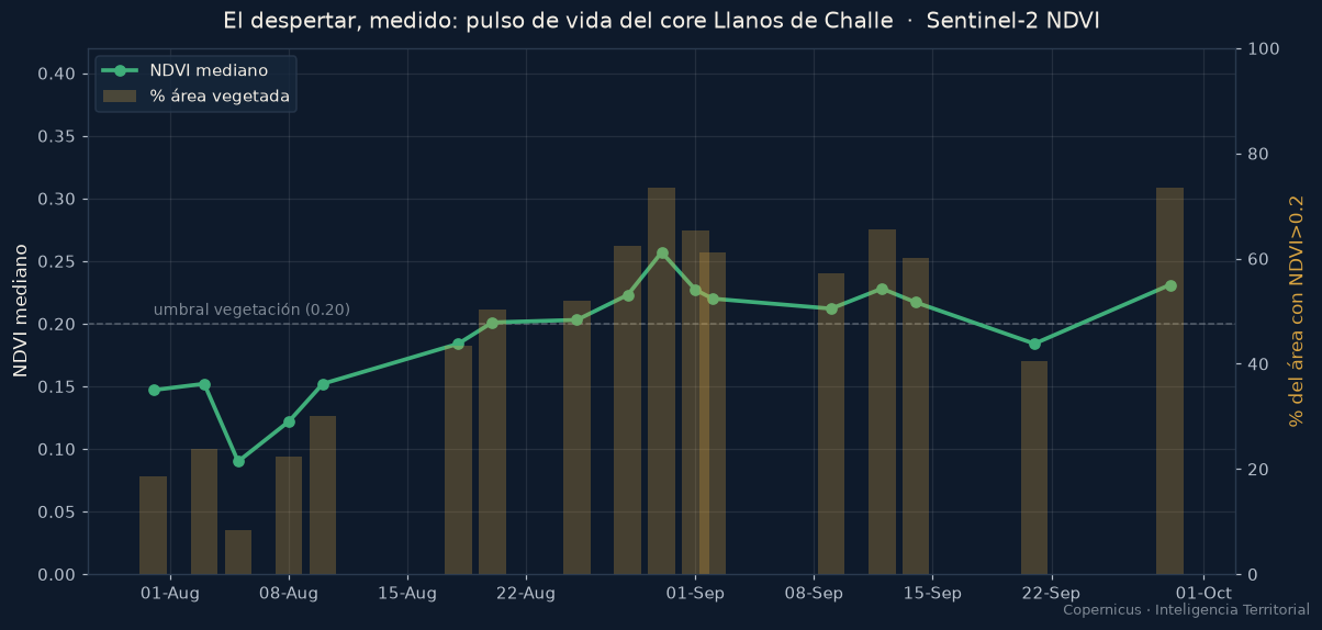
The NDVI —a satellite index that measures vegetation vigour— translates that awakening into a curve. Over the core of Parque Nacional Llanos de Challe, the signal of life climbs from bare-soil values (~0.10) to cross the vegetation threshold and sustain itself: today, nearly three-quarters of the core is vegetated where previously there was only sand.
Before and after, on the same ground
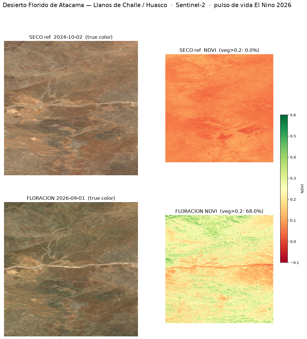
The most direct way to observe the phenomenon is to compare the same area in two states: the dormant desert and the ongoing flowering. In 2024 —a year of near-zero flowering, barely 3% of its potential— this sector was bare. In 2026, it greens.
The full footprint of the awakening
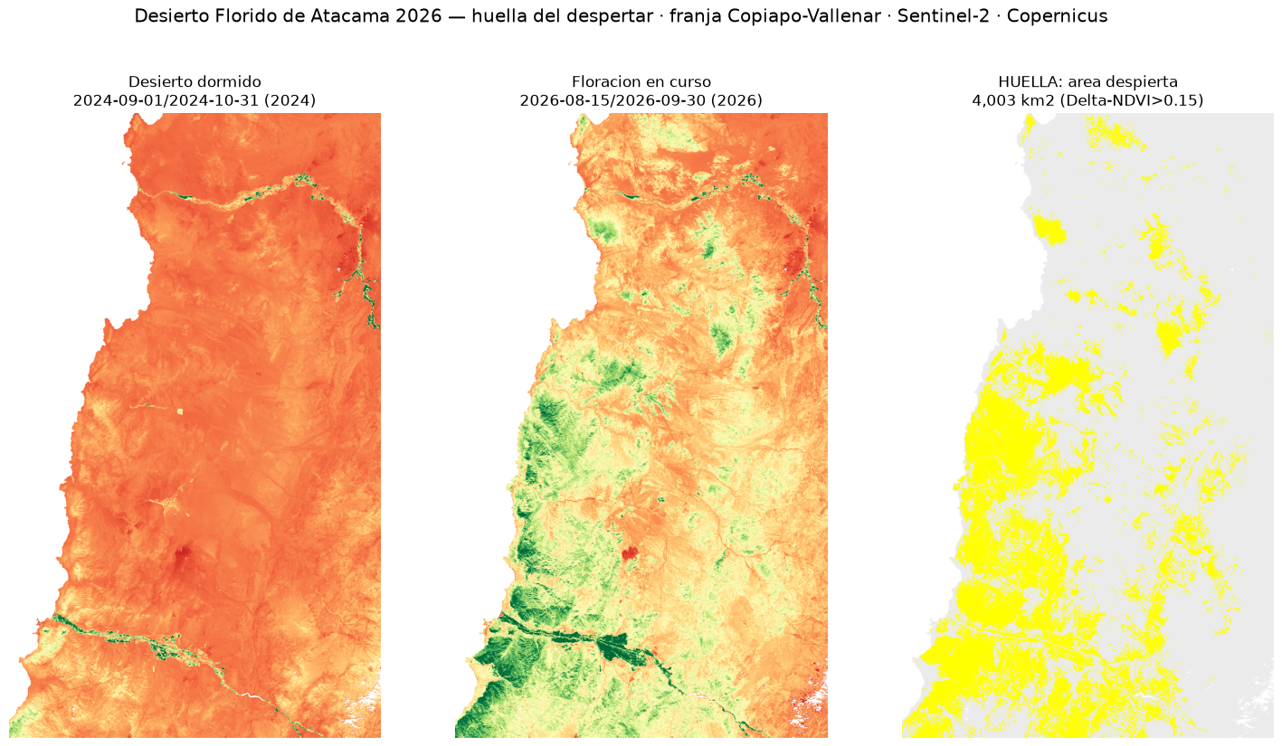
Scaling the same method to the entire Copiapó–Vallenar strip draws the greening footprint: every pixel where vegetation increased relative to the dormant desert (Δ-NDVI > 0.15). This is the method we use to map burn scars, applied in reverse: instead of burned area, area that returned to life.
How to read this number
What the footprint measures. The Δ-NDVI detects the green pulse: the biomass of germinating plants. The colour explosion —the pink of the pata de guanaco, the red of the garra de león— is a subset of that greening that bursts at the peak. 'Awakened area' is area that greened, not necessarily open flowers in every pixel.
Why 4,003 and not 15,000. We are at the leading edge of the event. Today's figure is the footprint measured as of 30 September —about one-quarter of the peak that CONAF projects for late October—. It is not an estimate: it is what has already greened. The footprint grows with the event, and this page updates until it captures the maximum.
What it is compared against. The dormant desert is defined using 2024, a year of near-zero flowering (~3% of its potential): a clean reference of resting soil. All green appearing in 2026 that was absent in 2024 is awakening, not noise.
The phenomenon, in images
A journalistic record of the event on the ground, to put a face to what the satellite measures from above:
Technical specifications
| Parameter | Value |
|---|---|
| Sensor | Sentinel-2 L2A (Copernicus) |
| Index | NDVI · Δ-NDVI (threshold 0.15) |
| Footprint resolution | 100 m/pixel |
| Analysed strip | Copiapó–Vallenar · 16,179 km² |
| Reference (dormant) | Sep–Oct 2024 |
| Flowering (event) | 15 Aug → 30 Sep 2026 |
| Awakened area as of 30 Sep | 4,003 km² (24.7%) |
| Data access | STAC Earth Search · open, no registration required |
A territory, an asset, or an event you need to measure from space? The engine is the same for any signal: water, vegetation, construction, heat, or risk.
Request a diagnosis